Mutley's Hangar Big VFR Adventure
LEG 2: EGTE-EGHD (Exeter-Plymouth)
This was only a short trip, but was a constant
battle along the way. The winds were so strong that even at full power
the Beaver was only showing indicated airspeed just above a stall. The
winds were continually shifting and doing so with great force, here’s
how it happened...
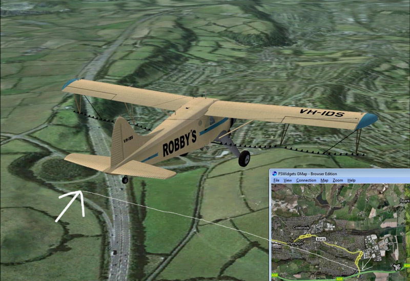
As I am using the VFR Real Scenery I thought I might as well try and fly
IFR, or I Follow Roads! I entered my route into Google Maps and shortly
after departure and flying over what looked like some quarries, I would
pick up the A38 which after meandering around for a few miles should
take me across the end of runway 31 at Plymouth. This was good because
the winds were blowing from 273 degrees at 35 knots over at Plymouth, so
I anticipated being asked to land on runway 31. Just to make sure that I
was following the correct mode I was also flying with FS Widget’s GMap,
a fantastic freeware tool that connects to Google Maps and places your
aircraft at the correct point as you fly along. This would also be a
good test of how accurate the scenery is!
 Click to enlarge image |
Sure enough I picked up the A38 as planned
and made sure I could view it well out of the left hand side of
the aircraft. I was able to pick out it’s route quite a way into
the distance so didn’t change direction too much, just kept the
road insight. I cruised along at 2,500 feet and the scenery was pin sharp at all times, and after constantly referring back to GMap, I was satisfied that the road I was following was the A38! This flight was only 35 miles long, so it didn’t take long for me to pick out the airport in the distance. |
|
I contacted the tower and set myself for a landing on runway 31, as
planned. Upon approaching the airport the airfield itself was raised
quite a bit above the rest of the land, this is no doubt down to
something Microsoft have done, but it still looked a bit ugly. As I got closer to the runway I almost had to perform a go-around and divert to my alternate airport as there had been what would appear to be a landslide on the runway! I checked my airspeed, and couple with the crazy headwind buffeting us around, I figured that the aircraft would be able to land halfway down the runway and stop with room to spare, and this was the case (thankfully). |
Click to enlarge image |

Landslide
on the runway!
The challenge was not over yet though as the winds were now trying to flip my poor aircraft over. Eventually we made it to the ramp and made sure she was tied down straight away. Then it was back to the briefing room to plan our next flight....
LEG 3: EGHD-EGGD (Plymouth-Bristol)
One thing I had decided before I started this
adventure was that it would be flown real-time. If it was night in the
real world, I would fly at the same time with the same weather
conditions in the simulated world.
So tonight would see me make the first night flight of the adventure
with a short 90 mile flight to Bristol. On a night that was just
above freezing we departed Plymouth and turned north and head over
Dartmoor and Exmoor National Parks before turning east and flying along
the Bristol Channel and over Weston-Super-Mare before flying a left
handed traffic pattern to land on runway 27 at Bristol Airport!
 Click to enlarge image |
 Click to enlarge image |
The flight itself was fairly uneventful apart from
some severe pockets of turbulence over Dartmoor as we climbed to our
cruise altitude of 5,500 feet. From this height we were able to take in
the spectacular views of the National Parks which were very well lit by
the moon.
Apart from a few clouds our view was more or less unlimited on
this cold night. As we made the right turn to fly up the channel it was
a welcome relief to see the lights of the city coming into view.
Although the time over the National Parks had been great for
sightseeing, the whole area looked a bit deserted but this is how I
would expect to see the area at 8pm on a Monday!
Around 20 miles from Bristol I contact the tower and requested a full
stop landing on runway 27, which was granted. I made a slow descent down
to 1,500 feet and after battling with a little more turbulence on base
leg was able to make a nice soft landing.
The approach was a little
eerie due to it being mainly over fields and the VFR Scenery has
depicted this very well as there is very little ground lighting to guide
you in. I certainly wouldn’t have liked to make a forced landing in a
field tonight!
LEG 4: EGGD-EGFG (Bristol-Swansea)
The weather today looked as though it would be great for this short hop
to Swansea. Our route today will take us north of Bristol overhead
Filton airport, then turning west towards the Brecon Beacons before
heading down to Swansea for a landing by the sea.

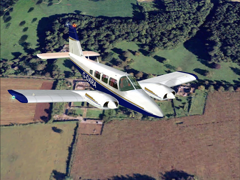
I opted to use the Piper Seneca from Just Flight’s
Flying Club package today, an aircraft which doesn’t get too regular an
outing from me, but I thought she would be perfect for this trip. We
departed from Bristol and as we passed though 1,000ft we made a sweeping
turn back over the airport to take in the scenery as we positioned for
the short leg to Filton airport.
As we moved on up to 4,500 feet the winds began to get progressively
worse with the aircraft been shaken around lots; it was a tough job to
keep her on track. The scenery as we departed Bristol was amazing, as I
hope the pictures can testify. The level of detail us superb at all
levels and I wasn’t left waiting for the scenery areas to load up, they
were there instantly.
After reaching Filton we turned towards the Brecon Beacons and as we
passed over the airport it was easy to pick out the Airbus Factories
below. The Brecon Beacons were a fantastic sight with the undulating
land depicted superbly; I was almost expecting to see a platoon of SAS
soldiers training as we passed by.
 Click to enlarge image |
 Click to enlarge image |
About 20 miles from Swansea I announced my intentions to land on runway
28 and began to descend down to 1,500 feet.
On reaching 1,500 feet the
winds were horrible and I was forced to fly the pattern at 700 feet as
this was the only altitude where I was able to have the aircraft steady.
We made a late turn to line up with the runway so that we were able to
take in the coastline as we approached. Just Flight have done a
fantastic job of making the coastlines look highly realistic in this
scenery, and coastal approaches are a lot more fun that with the default
scenery. After a short descent to the runway we landed safely and taxied
off to the ramp to add some more fuel for the next leg which will take
us to Welshpool .
Continued .....