Captain Coffee 2,030 Posted June 7, 2015 Report Share Posted June 7, 2015 I added Pago Pago to my ORBx collection. Love to island hop. I used to run an Airhauler base in the Somoas because of the relative close flights between the 7-8 airfields in the chain. Fun and relatively picturesque hauling with a couple challenging fields. I'll be reopening a company there now...the picturesque part just got a huge shot in the arm. A few "pop in" shots in the CH-47 I made while deciding which location to open a new shop...it certainly WON'T be HI36...glad I did the exercise, because I recall starting there before as it was the cheapest of the lot iirc. Pago Pago NSTU: FAQ, Tau Island - American Somoa. This is clearly not on the list of airports worked on by ORBx...but it is/Was on the FSX map previously, now there seems to be nothing there for HI36...I was unceremoniously plopped down in the middle of a stand of trees when I first loaded this area up. Closest place to land my chopper was this (most likely a roof from the photo textures) circular area nearby. Looks like a spot close enough for a custom Airhauler Chopper pad anyhow, because AH will probably still generate jobs for this "airfield". z08: Ofu Village Apt. Ofu - American Somoa. NSFI: Fagali - Somoa. Mind the flocks of birds. NSFA: Faleolo Intl, Apia - Somoa NSMA: Maoto Airport, Salelologa - Samoa (I think this will be my starter base for Air Hauler...close to 3 other fields, decent size runway, has a couple parking spots to fit a couple Twotters.) NSAU: Asau Airport, Asau - Samoa Cheers. Thanks for joining me on the reconnoiter run. 1 Link to post Share on other sites
Captain Coffee 2,030 Posted June 7, 2015 Author Report Share Posted June 7, 2015 Interesting. NSAU and NSMA weren't recongnized by AirHauler till updating after installing this addon. Cool. Two new fields. Unfortunately, HI36 is still listed there, and listed as a 0ft runway...but no pad in the location, again, except that circular patch I found nearby...something I'll have to keep in mind for when a job pops there. Link to post Share on other sites
jaydor 345 Posted June 7, 2015 Report Share Posted June 7, 2015 Pidgin"inchgo pritee like um fair fellow takum foto of place I'm likin live the lifetime".. "likum pngman he blowed the poison dart onto kelihopter to window-screen in 1,3,& 4".. :D Link to post Share on other sites
Captain Coffee 2,030 Posted June 7, 2015 Author Report Share Posted June 7, 2015 OMG...haha. Nice one James. Took me a minute to figure out what you were on about....hehe. fyi, that is a "Wind tell" for those unfamiliar with this chopper...a very useful feature to help figure out your relative side motion and cross winds. 1 Link to post Share on other sites
UKJim 502 Posted June 8, 2015 Report Share Posted June 8, 2015 Some interesting shots there - looks like a good place to take out the twotter Link to post Share on other sites
wain 879 Posted June 8, 2015 Report Share Posted June 8, 2015 Nice shots matt....bought my first orbx airfield yesterday... KORS...love it..i can see me getting more....detail is great but big orbx issues for me in fsxse luckily i have p3d... Wayne Link to post Share on other sites
dodgy-alan 1,587 Posted June 8, 2015 Report Share Posted June 8, 2015 Very nice. Link to post Share on other sites
mutley 4,489 Posted June 8, 2015 Report Share Posted June 8, 2015 Lovely shots Matt. The islands and airfields in the eastern area of the region are truly Treasure Island material! Link to post Share on other sites
Captain Coffee 2,030 Posted June 8, 2015 Author Report Share Posted June 8, 2015 From Yesterday's haul across the entire region in this Very nice sharky Twotter...Thanks for these paints Jankees, they are generic enough to use anywhere I fly twotters. This is the best "Airport" deal ever...so much territory is covered by the Pago Pago scenery...including a whole lot of water of course . Cheers! Link to post Share on other sites
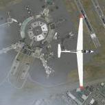
Andrew Godden 934 Posted June 9, 2015 Report Share Posted June 9, 2015 Matt, I was doing some extra research on HI36. This was definitely only ever a helipad and looking at it on Google Earth it appears to be reasonably representative of typical helipads in the Pacific Islands - very tight. Having worked in PNG and some of the Pacific Islands on helo ops in a previous life, what they call a helipad is often a spot on the ground with just enough rotor and tail boom clearance and some markings to aim for. There was a similar one at Isurava in the FTX: PI AYPY Jacksons International Airport scenery. I think Orbx have, again, actually captured the essence of HI36 as it is in the real world. In other words, to be only attempted by serious rotorheads. Cheers Andrew 1 Link to post Share on other sites
stu7708 244 Posted June 9, 2015 Report Share Posted June 9, 2015 Great shots, I fear I must pick this package up in a very near future!! Looking at the area around HI36 in Google Earth the shot you provided looks spot on, but I can't help but wonder where that heli-pad actually is located, because as you say those circular can't be it. The brown one is most likely a roof of some sort and the grey bit might be a stone wall. On google Earth it looks like there is a clearing in the woods just south of the buildings, with a small road going up to it, could that be it if it's present in FSX?? Link to post Share on other sites
Captain Coffee 2,030 Posted June 9, 2015 Author Report Share Posted June 9, 2015 I think you are correct Stu...the clearing at that road is probably the actual pad. Unfortunately, the spot you are dumped out in is the spot shown on Google earth, in the middle of a bunch of trees. This the RL spot in the ORBx scenery, pretty darn accurate compared to Google earth, cept for the trees in the middle. The road is there too. There is still room to get a copter in though. This is where FSX dumps you when you select HI36...but, note the accuracy compared to Google Earth...extremely good job ORBx folks!!! ORBx Earth: The Earth: Thanks for helping me track this down Andrew and Stu. Link to post Share on other sites
stu7708 244 Posted June 9, 2015 Report Share Posted June 9, 2015 Glad to be of assistance Looks like the position where you spawn in FSX corresponds fairly well with the misplaced airport marker in Google Earth as well Link to post Share on other sites
Andrew Godden 934 Posted June 9, 2015 Report Share Posted June 9, 2015 Glad to be of assistance Looks like the position where you spawn in FSX corresponds fairly well with the misplaced airport marker in Google Earth as well Yes, the two concentric circles at the 11 o'clock position to the airport marker and to the right of the large building is the actual location of the helipad and also coincides with ground markings in the FTX: PI NSTU scenery. Cheers Andrew Link to post Share on other sites
Sabre 28 Posted June 9, 2015 Report Share Posted June 9, 2015 Very nice collection of shots chaps, shows off the scenery very nicely indeed - something else to add to the list of things to buy when my visa card recovers 1 Link to post Share on other sites
Captain Coffee 2,030 Posted June 9, 2015 Author Report Share Posted June 9, 2015 Glad to be of assistance Looks like the position where you spawn in FSX corresponds fairly well with the misplaced airport marker in Google Earth as well Yes, the two concentric circles at the 11 o'clock position to the airport marker and to the right of the large building is the actual location of the helipad and also coincides with ground markings in the FTX: PI NSTU scenery. Cheers Andrew hmmm...I don't know. You may be correct, it is hard to tell from the google maps images as it doesn't have a Street View for the area ...but those concentric rings look like some kind of fence...perhaps a trellis? In the sim the spot is EXTREMELY tight and I landed my Chop Chop on what turned out to be the building roof during my first visit. My money is on the dirt clearing at the end of the crappy road found thanks to you guy's help...which is where I will place a custom Air Hauler heli pad for future hauling. Cheers. Link to post Share on other sites
stu7708 244 Posted June 9, 2015 Report Share Posted June 9, 2015 Those two circles might even be A SHRUBBERY!! :-) 1 Link to post Share on other sites
Captain Coffee 2,030 Posted June 9, 2015 Author Report Share Posted June 9, 2015 Rodger that Stu! Link to post Share on other sites
Tim Harris 1 Posted June 11, 2015 Report Share Posted June 11, 2015 Gday folks, been enjoying the screenshots and noticed the discussion on the 'missing in action' HI36 Hi36-Tau Airport: was a 661 x 30 m private airstrip made of compacted coral, dirt and grass, it existed up until the very early 90s, it was a busy little airport in its day, being a tricky location it had 3 accidents during its time: 1979 - Twinotter - Heavy landing caused plane to slide and crash into the trees. all OK 1984 - Twinotter - Elevator control cable snapped on final, causing the nose to rise suddenly, pilot steered it in using throttle and flap control, but ultimately collided with the terminal building and a vehicle. 1 fatality 1989 - Twinotter - Descended fast on final approach. Application of full power couldn't prevent the aircraft from impacting the ground short of the runway. all OK Then sometime around 1993>> ish, the larger FAQ-Fitiuta Airport was built to replace it and is seen in our rendition of the Manu'a islands, Tau Airport was left to melt into the bush so we modeled it just the way it currently is Apart from that info, I know absolutely nothing else about HI36, could not even find a single picture...! Little piccy below from GE showing the approx location and orientation Cheers! Tim. Link to post Share on other sites
wain 879 Posted June 11, 2015 Report Share Posted June 11, 2015 cheers Tim, good bit of knowledge there, interesting stuff...... Link to post Share on other sites
Captain Coffee 2,030 Posted June 11, 2015 Author Report Share Posted June 11, 2015 Thanks for that Tim (and for the brilliant work on the Pago scenery...very fun place to fly)! Looks like the roadway was the entrance to the strip then. I did in fact get a cargo assigned to HI36 last night, so I leased a Milviz Bell 404 and created an AH parking spot in that clearing by the end of the road...my guess is that is the previous location of the terminal. Link to post Share on other sites
dolf8857 640 Posted June 13, 2015 Report Share Posted June 13, 2015 Nice set! Link to post Share on other sites
Recommended Posts
Please sign in to comment
You will be able to leave a comment after signing in
Sign In Now